Winter Storm Watch in Effect Friday Morning Through Saturday Morning
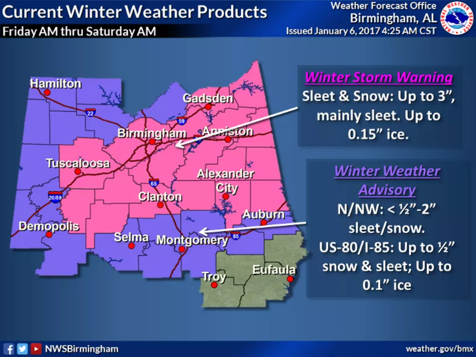
The chances of seeing snow in West Alabama are looking much higher, as the National Weather Service in Birmingham has already issued a Winter Storm Watch in effect from Friday (January 6) morning through Saturday (January 9) morning.
While earlier forecasts seemed to suggest that we'd see a light dusting of snow--if anything--the issuance of a Winter Storm Watch this far in advance seems to suggest a much higher potential for a significant weather event. You can read the full text of the advisory below:
...WINTER STORM WATCH IN EFFECT FROM FRIDAY MORNING THROUGH
SATURDAY MORNING...THE NATIONAL WEATHER SERVICE IN BIRMINGHAM HAS ISSUED A WINTER
STORM WATCH...WHICH IS IN EFFECT FROM FRIDAY MORNING THROUGH
SATURDAY MORNING.* EVENT...A STORM SYSTEM IS EXPECTED TO DEVELOP WITH POTENTIAL
WINTER WEATHER IMPACTS.* TIMING...FRIDAY MORNING THROUGH SATURDAY MORNING.
* LOCATION...LARGEST IMPACTS WILL BE POSSIBLE, MAINLY BETWEEN THE
I59 AND I20 CORRIDORS IN THE WATCH AREA. SOME SLEET IMPACTS ARE
POSSIBLE AS FAR SOUTH AS THE I85 CORRIDOR.* ACCUMULATIONS...2 TO 3 INCHES OF SNOW ARE POSSIBLE IN THE WATCH
ZONES FROM THE BIRMINGHAM METRO AREA, EAST AND NORTHEAST. LESS
THAN 2 INCHES ARE POSSIBLE IN OTHER OUTLYING AREAS TO THE WEST
AND NORTHWEST OF THE METRO.PRECAUTIONARY/PREPAREDNESS ACTIONS...
A WINTER STORM WATCH MEANS THERE IS A POTENTIAL FOR SIGNIFICANT
SNOW...SLEET...OR ICE ACCUMULATIONS THAT MAY IMPACT TRAVEL.
CONTINUE TO MONITOR THE LATEST FORECASTS.
More From Alt 101.7


