Update on Slow-Moving Sally and Potential Impacts for our Area
Update on Slow-Moving Sally and Potential Impacts for our Area

[Update: Monday, September 14, 2020, at 4:15 pm]
As expected, Hurricane Sally has become stronger with strengthening probable for tonight as well. It is currently a category 2. Also, there has been a slight shift in the track of Sally to the east.
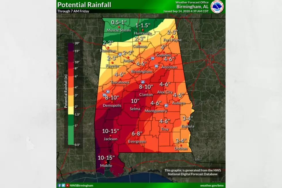
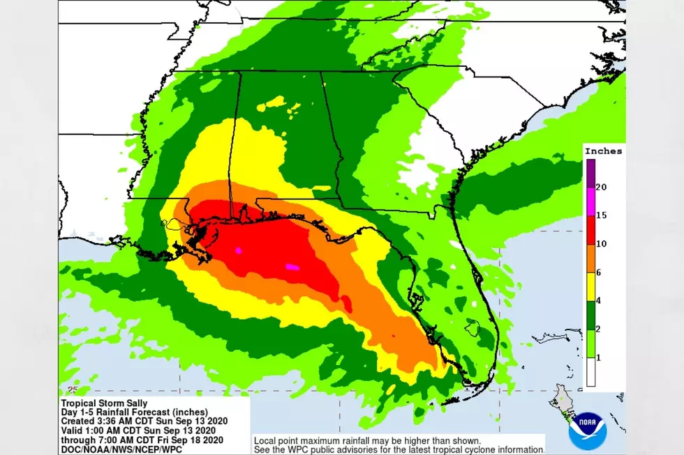
Main concerns for our listening areas are the slow-motion of Sally, which will bring more prolonged activity. Our listening area has a range of projected rain totals from 8 to 10 inches to 2 to 3 inches. See the potential rainfall map from the National Weather Service.
Potential Rainfall for our listening areas:
8-10” = Bibb, Dallas, Greene, Hale, Marengo, Perry, and Sumter
4-6” = Jefferson and Tuscaloosa
2-3” = Fayette, Lamar, Pickens, and Walker
[Update: Monday, September 14, 2020, at 11:50 am]
Sally has strengthened into a hurricane. It is still on track to approach the northern Gulf Coast. Also, this hurricane is still a slow-moving storm but could rapidly intensify over the next few hours.
From the National Hurricane Center, “Data from a NOAA Hurricane Hunter aircraft investigating Sally indicate the system has rapidly strengthened to a hurricane, with maximum sustained winds of around 85 mph (140 km/h) with higher gusts. The estimated minimum central pressure is 985 mb (29.09 inches).”
Possible Impacts for Central Alabama:
There is a Flash Flood Watch for portions of Central Alabama, East Central Alabama, and West Central Alabama. This is in effect from late Tuesday night through Thursday morning. Click here for all the counties provided by the Tuscaloosa Thread.
The Storm Prediction Center has for areas along & south of U.S. 80 under a marginal risk for severe weather.
Breezy conditions on Wednesday (15-25 mph and possible gusts up to 30 mph)·
Heavy rainfall late Tuesday – Thursday with the highest totals being west of I-65· Projected 3 to 6 inches for North and Central Alabama
Localized/river flooding possible
Conditional risk of a few brief tornadoes on Wednesday and Thursday
Updated Watches and Warnings from the National Weather Service:
A Storm Surge Warning is in effect for: Port Fourchon, Louisiana to the Alabama/Florida border. Lake Pontchartrain, Lake Maurepas, and Lake Borgne. Mobile Bay
A Hurricane Warning is in effect for: Morgan City, Louisiana to the Alabama/Florida border. Lake Pontchartrain and Lake Maurepas, including metropolitan NewOrleans
A Tropical Storm Warning is in effect for: Alabama/Florida border to Indian Pass Florida. Intracoastal City Louisiana to west of Morgan City
A Tropical Storm Watch is in effect for: Indian Pass to Ochlockonee River Florida
(Source) For more from the National Hurricane Center, click here.
[Update: Monday, September 14, 2020, at 11:10 am]
Alabama Governor Kay Ivey has issued a State of Emergency in advance of Tropical Storm Sally. For more information please click here to head over the Tuscaloosa Thread.
[Update: Monday, September 14, 2020, at 7:35 am]
Sally is still a slow-moving system that is moving west-northwest at nine mph. Currently, the wind speeds are 60 mph and still has the potential to continue to strengthen into a hurricane.
The projected landfall is approximately around the mouth of the Mississippi River, with the center passing over New Orleans, which could take place late Monday or Tuesday.
Areas of concern
- Likely to produce life-threatening storm surge for southeast Louisiana, Mississippi, and Alabama
- Flash Flooding along portions of the Northern Gulf Coast
- Flooding rain that extends further inland across the Southeast
- The slow-moving nature of Sally could mean sustained impacts
Governor Kay Ivey issued a statement that reminded us that “as we head into a new week, we are keeping a close eye on Tropical Storm Sally. It is likely that this storm system will be impacting Alabama’s Gulf Coast. While it is currently not being predicted as a direct hit to our coastal areas, we know well that we should not take a threat lightly.”
Central Alabama Impacts:
After Sally makes it landfall, the system should weaken and track through southern Mississippi Tuesday evening. The timing for our area is for Wednesday and early Thursday, more than likely as a tropical depression. Again, I stress that any change in Sally’s track could change our local impacts.
There is a Flash Flood Watch for portions of Central Alabama, East Central Alabama, and West Central Alabama. This is in effect from late Tuesday night through Thursday morning. Click here for all the counties provided by the Tuscaloosa Thread.
The Storm Prediction Center has for areas along & south of U.S. 80 under a marginal risk for severe weather.
Breezy conditions on Wednesday (15-25 mph and possible gusts up to 30 mph)·
Heavy rainfall late Tuesday – Thursday with the highest totals being west of I-65· Projected 3 to 6 inches for North and Central Alabama
Localized/river flooding possible
Conditional risk of a few brief tornadoes on Wednesday and Thursday
The National Weather Service Birmingham noted on their Facebook page, “We're still trying to pinpoint exact threats, areas & timing. Much uncertainty in the track remains. Please check back frequently for more info.”
Current warnings and watches:
A Storm Surge Warning is in effect for:
- Port Fourchon, Louisiana to the Alabama/Florida border
- Lake Pontchartrain, Lake Maurepas, and Lake Borgne
- Mobile Bay
A Hurricane Warning is in effect for:
- Morgan City, Louisiana to the Mississippi/Alabama border
- Lake Pontchartrain and Lake Maurepas, including metropolitan New Orleans
A Tropical Storm Warning is in effect for:
- Mississippi/Alabama border to Indian Pass Florida
- Intracoastal City, Louisiana to the west of Morgan City
A Hurricane Watch is in effect for:
- The Alabama Gulf Coast
I do stress that any change in variables with Sally could change the predictions for our area. It is always best to stay informed.
(Source) For more from Governor Kay Ivey, click here. For more from the National Weather Service Birmingham Facebook page, click here.
The Colors Of The Sky
More From Alt 101.7


