Hurricane Laura: Louisiana and Texas Border Brace For the Worst
Hurricane Laura: Louisiana and Texas Border Brace For the Worst
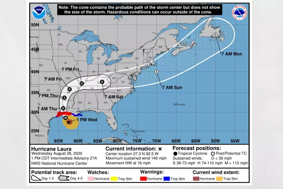
As we are all on the edge of our seat, Hurricane Laura inches closer and closer to the Louisiana and Texas border. Laura is bringing winds of 150 mph, has devastating and could grow in strength over the next few hours before landfall. The next hurricane category is 5, where the Saffir Simpson hurricane wind scale would be winds greater than 157 miles per hour.
According to the National Weather Service, Hurricane Laura is at a point where “winds are increasing as extremely dangerous hurricane Laura takes aim at the northwest gulf coast, catastrophic storm surge, extreme winds, and flash flooding expected along the northwest gulf coast tonight.”
Let me be honest; as a weather forecaster, these storms are undoubtedly fascinating to monitor. However, I am fearful at the same time due to the considerable threat to life and property. I am sending positive thoughts to those in the path of Hurricane Laura. At the time of this story, tropical storm force winds are being felt in southern Louisiana and southeast Texas. According to CNN Weather, here is the timeline of Laura based on city and conditions.
Beaumont and Port Arthur
- Tropical storm winds (39 mph+): 9 p.m. ET Wednesday to 9 a.m. ET Thursday
- Hurricane force winds (75 mph+): 12 a.m. ET to 5 a.m. ET Thursday
- Peak winds gusts: 110-120 mph
- Total rainfall expected: 6 to 8 inches
- Peak storm surge: 10-15 feet
- High tide: 3 a.m. ET to 4 a.m. ET Thursday
Lake Charles, Louisiana
- Tropical storm winds (39 mph+): 9 p.m. ET Wednesday to 10 a.m. ET Thursday
- Hurricane force winds (75 mph+): 12 a.m. ET to 7 a.m. ET Thursday (peak between 2 a.m. ET and 5 a.m. ET)
- Peak winds gusts: 110-120+ mph
- Total rainfall expected: 7-10 inches
- Peak storm surge:15 to 20 feet
- High tide: 6 a.m. ET Thursday
Galveston
- Tropical storm winds (39 mph+): 8 p.m. ET Wednesday to 4 a.m. ET Thursday
- Hurricane force winds (75 mph+): Not expected – but peak winds between 11 p.m. ET and 2 a.m. ET
- Peak winds gusts: 45-55 mph
- Total rainfall expected: 1-3 inches
- Peak storm surge: 2 to 4 feet
- High tide: 2 a.m. ET to 3 a.m. ET Thursday
Houston
- Tropical storm winds (39 mph+): 8 p.m. ET Wednesday to 4 a.m. ET Thursday
- Hurricane force winds (75 mph+): Not expected
- Peak winds gusts: 35-45 mph
- Total rainfall expected: less than 2 inches
- Peak storm surge: 3 to 5 feet (along coastal Harris/Galveston Bay)
- High tide: 7 a.m. ET Thursday
(Source) For more from the National Weather Service, click here. For more from CNN Weather, click here.

Hurricane Terms You Need to Know
More From Alt 101.7


