Alabama Get Ready: Possible Dangerous Severe Weather Wednesday
Townsquare Media is in Operation Storm Watch mode. We are encouraging you to stay very aware of weather conditions on Wednesday. Our coverage areas have the potential to experience a dangerous level of severe weather. Be sure you have multiple ways to get weather information. A great resource is our free app.

Editor Note: Please remember that there are many variables in severe weather. Information could adjust as conditions change and new model information is available. Adjustments could be made throughout Tuesday in preparation for Wednesday.
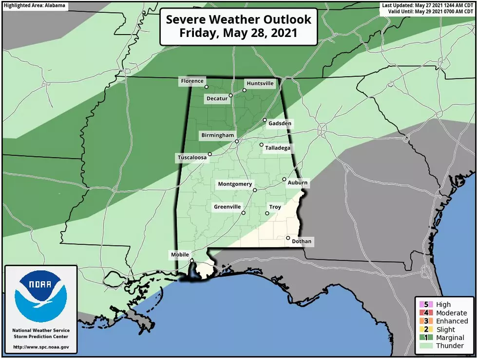
Our coverage area is under a Moderate Risk which is level 4 out of 5.
This system is affecting much of the south, including Alabama. The Weather Channel commented that “the greatest threat of tornadoes is expected from parts of central and eastern Arkansas and far southeast Missouri into western Tennessee, northern and central Mississippi and much of Alabama. There is the possibility of strong tornadoes in this corridor.”
Wednesday Timeline is the afternoon, into the evening, and overnight hours.
North and West of Birmingham - Wednesday 1 pm until Thursday 1 am
Tuscaloosa, Birmingham, Anniston, Gadsden - Wednesday 3 pm until Thursday 3 am
Montgomery - Wednesday 6 pm until Thursday 6 am
James Spann, ABC 33/40, and Townsquare Media Tuscaloosa Chief Meteorologist noted his thoughts on the AlabamaWX Weather Blog, “DANGEROUS SETUP TOMORROW AFTERNOON/NIGHT: A compact/vigorous upper low initially over the Oklahoma area is forecast to move steadily eastward through the day, spreading strong flow aloft and a broad zone of enhanced ascent across the Deep South. This, combined with unstable air and high shear values, will set the stage for strong to severe thunderstorms. SPC now has a decent part of the state in a “moderate risk” (level 4/5)… this includes Birmingham, Montgomery, Tuscaloosa, Anniston, Gadsden, and Florence. The rest of the state is in either an enhanced or slight risk.”
The National Weather Severe in Birmingham lets us know that the severe threat is increasing for Wednesday afternoon and night. . “Threats include strong tornadoes, large hail up to golf ball size, and damaging winds up to 80 mph.”
(Source) Click here for more information on the Weather Channel. Click here to follow the Facebook Page for James Spann. Click here for more information from the AlabamaWX Weather Blog. For more from the National Weather Service Birmingham, click here.
KEEP READING: Get answers to 51 of the most frequently asked weather questions...
KEEP READING: What to do after a tornado strikes
More From Alt 101.7